TPM Toolbox
This website is the home of the FHWA Transportation Performance Management Toolbox.
What is transportation performance management?
Transportation Performance Management (TPM) is a strategic data-driven approach that uses system information to make investment and policy decisions to achieve performance goals. By adopting TPM principles, transportation agencies can ensure the right bundle of projects is selected to produce desired performance outcomes.
Why should transportation agencies adopt transportation performance management?
TPM leads to improved performance. The condition of bridges, pavement, transit vehicles, and bike infrastructure will improve within a TPM practice, leading to improved conditions for system users in areas such as safety, mobility, and public and environmental health. Using data, agencies can allocate resources to address regional priorities and ensure that every dollar is spent to impact performance in a positive way.
What is the purpose of this website?
The tools available here are intended to assist staff from transportation agencies in learning about and implementing TPM practices. The Guidebook and Resources tools enable you to learn more about TPM while the Self-Assessment allows you to assess your current TPM capabilities and identify actions to improve those capabilities. Information within the Toolbox is geared towards both state and local transportation agencies.
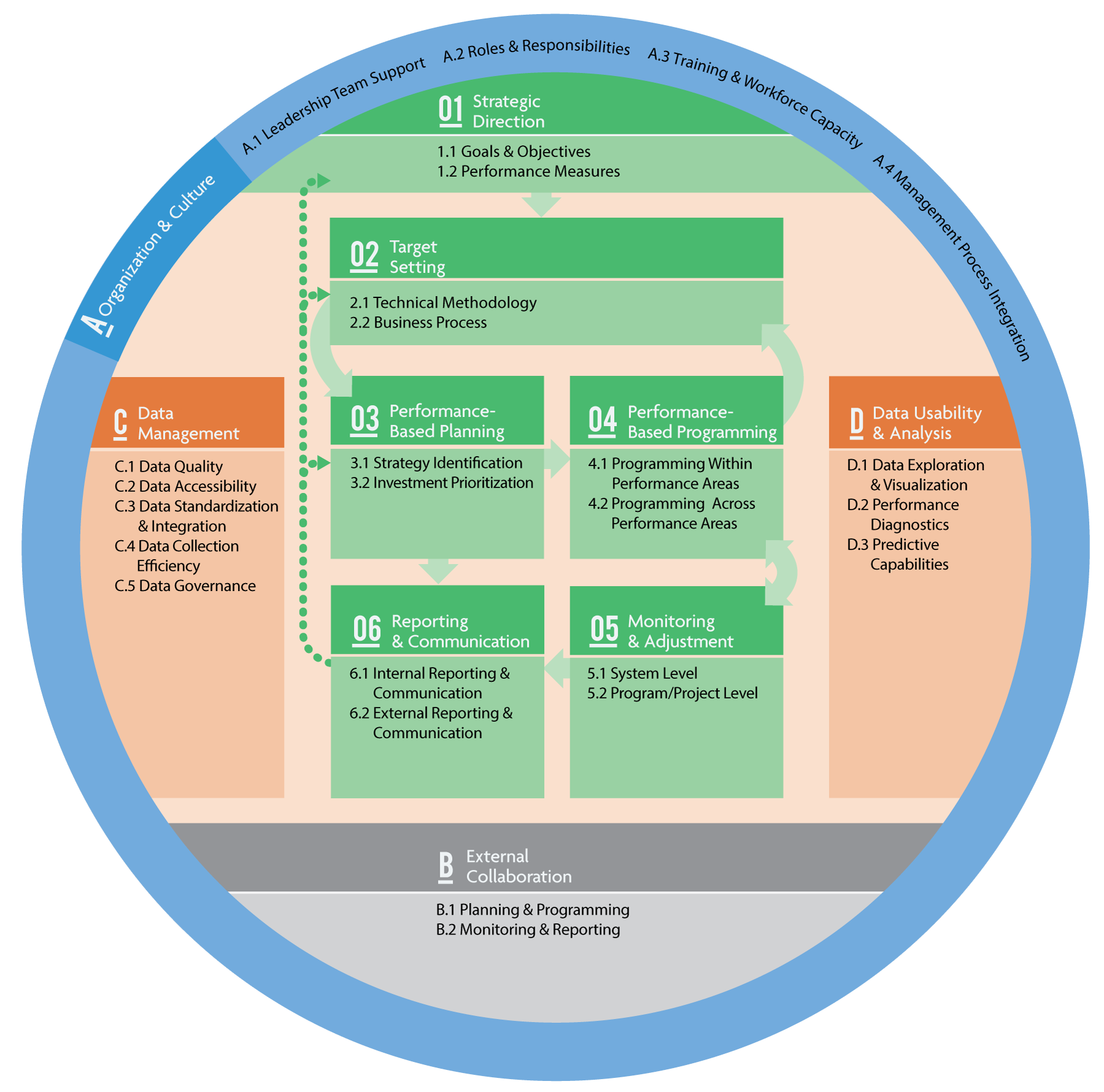
The TPM Framework
[drawattention ID="1560"]
Definitions for each component are provided below; subcomponent definitions are contained in guidebook chapters.
Component 01. Strategic Direction
Definition: The establishment of an agency’s focus through well-defined goals and objectives, enabling assessment of the agency’s progress toward meeting goals and objectives by specifying a set of aligned performance measures. The Strategic Direction is the foundation upon which all transportation performance management rests.
Definition: The use of baseline data, information on possible strategies, resource constraints, and forecasting tools to collaboratively establish a quantifiable level of performance the agency wants to achieve within a specific time frame. Targets make the link between investment decisions and performance expectations transparent across all stakeholders.
Component 03. Performance-Based Planning
Definition: The use of agency goals and objectives and performance trends to drive the development of strategies and priorities in the long-range transportation plan and other performance-based plans and processes. The resulting planning documents become the blueprint for how an agency intends to achieve its desired performance outcomes.
Component 04. Performance-Based Programming
Definition: The use of strategies and priorities to guide the allocation of resources to projects that are selected to achieve goals, objectives, and targets. Performance-based programming establishes clear linkages between investments made and expected performance outputs and outcomes.
Component 05. Monitoring and Adjustment
Definition: A set of processes used to track and evaluate actions taken and outcomes achieved, thereby establishing a feedback loop to refine planning, programming, and target setting decisions. It involves using performance data to obtain key insights into the effectiveness of decisions and identifying where adjustments need to be made in order to improve performance.
Component 06. Reporting and Communication
Definition: The products, techniques, and processes used to communicate performance information to different audiences for maximum impact. Reporting is an important element for increasing accountability and transparency to external stakeholders and for explaining internally how transportation performance management is driving a data-driven approach to decision making.
Component A. Performance Management Organization and Culture
Definition: Institutionalization of a transportation performance management culture within the organization, as evidenced by leadership support, employee buy-in, and embedded organizational structures and processes that support transportation performance management.
Component B. External Collaboration and Coordination
Definition: Established processes to collaborate and coordinate with agency partners and stakeholders on planning/visioning, target setting, programming, data sharing, and reporting. External collaboration allows agencies to leverage partner resources and capabilities, as well as increase understanding of how activities impact and are impacted by external factors.
Definition: A set of coordinated activities for maximizing the value of data to an organization. It includes data collection, creation, processing, storage, backup, organization, documentation, protection, integration, dissemination, archiving, and disposal. Well-managed data are essential for a robust TPM practice.
Component D. Data Usability and Analysis
Definition: Existence of useful and valuable data sets and analysis capabilities available in accessible, convenient forms to support transportation performance management. While many agencies have a wealth of data, such data are often disorganized, or cannot be analyzed effectively to produce useful information to support target setting, decision making, monitoring, or other TPM practices.
About the site
This is the web resource for the FHWA Transportation Performance Management (TPM) Technical Assistance Program. The tools available here are intended to assist staff from transportation agencies in learning about and implementing TPM practices. Read more about this site...
